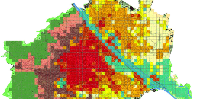
vienna map
Understanding the whole city as landscape. A multivariate approach to urban landscape morphology

Authors

  • Richard Stiles Vienna University of Technology, Faculty of Architecture and Regional Planning
  • Beatrix Gasienica‐Wawrytko Vienna University of Technology, Faculty of Architecture and Regional Planning
  • Katrin Hagen Vienna University of Technology, Faculty of Architecture and Regional Planning
  • Heidelinde Trimmel Vienna University of Technology, Faculty of Architecture and Regional Planning
  • Wolfgang Loibl AIT Austrian Institute of Technology
  • Tanja Tötzer AIT Austrian Institute of Technology
  • Mario Köstl AIT Austrian Institute of Technology
  • Stephan Pauleit Technische Universität München, Chair for Strategic Landscape Planning and Management
  • Annike Schirmann Technische Universität München, Chair for Strategic Landscape Planning and Management
  • Wolfgang Feilmayr Vienna University of Technology, Faculty of Architecture and Regional Planning

Downloads

DOI:

https://doi.org/10.7480/spool.2014.1.642

Abstract

The European Landscape Convention implies a requirement for signatory states to identify their urban landscapes which goes beyond the traditional focus on individual parks and green spaces and the links between them. Landscape ecological approaches can provide a useful model for identifying urban landscape types across a whole territory, but the variables relevant for urban landscapes are very different to those usually addressing rural areas. This paper presents an approach to classifying the urban landscape of Vienna that was developed in a research project funded by the Austrian Ministry for Transport, Innovation and Technology: ‘Urban Fabric and Microclimate Response’. Nine landscape types and a number of sub-types were defined, using a multivariate statistical approach which takes account of both morphological and urban climate related variables. Although the variables were selected to objectively reflect the factors that could best represent the urban climatic characteristics of the urban landscape, the results also provided a widely plausible representation of the structure of the city’s landscapes. Selected examples of the landscape types that were defined in this way were used both to simulate current microclimatic conditions and also to model the effects of possible climatic amelioration measures. Finally the paper looks forward to developing a more general-purpose urban landscape typology that allows investigating a much broader complex of urban landscape functions.

How to Cite

Stiles, R., Gasienica‐Wawrytko, B., Hagen, K., Trimmel, H., Loibl, W., Tötzer, T., Köstl, M., Pauleit, S., Schirmann, A., & Feilmayr, W. (2014). Understanding the whole city as landscape. A multivariate approach to urban landscape morphology. SPOOL, 1(1), 401–418. https://doi.org/10.7480/spool.2014.1.642

Published

2014-05-24

Plaudit

References

Berlin. (2002). Environmental Atlas. Berlin: Senate Department for Urban Development and the Environment. Retrieved from: http://www.stadtentwicklung.berlin.de/umwelt/umweltatlas/edua_index.shtml

Braun-Blanquet, J. (1932). Plant Sociology. The study of plant communities. New York, NY and London, United Kingdom: McGraw-Hill.

Breckle, S. W. (2002). Walter’s vegetation of the earth: the ecological systems of the geo-biosphere (p. 527). Berlin, Germany: Springer.

Bruse, M. (2004). ENVI-met 3.0: updated model overview. University of Bochum. Retrieved from: www.envi-met.com.
Bunce, R. G. H., Barr, C. J., Clarke, R. T., Howard, D. C., &

Lane, A. M. J. (1996). ITE Merlewood land classification of Great Britain. Journal of Biogeography, 23(5), 625-634.

Council of Europe. (2000). Council of Europe (2000a) European Landscape Convention, Florence (20.X.2000. ETS No. 176.). Strasbourg, France: Council of Europe. Retrieved from: http://conventions.coe.int/Treaty/en/Treaties/Html/176.htm

ESPON. (2007). ESPON Project 1.4.3, Study on Urban Functions (Final Report March 2007). Luxembourg, Luxembourg: ESPON. Retrieved from: http://www.espon.eu/export/sites/default/Documents/Projects/ESPON2006Projects/StudiesScientificSupportProjects/UrbanFunctions/fr-1.4.3_April2007-final.pdf

European Environment Agency. (2006). Urban morphological zones 2006. Copenhagen, Denmark: European Environment Agency (EEA). Retrieved from: http://www.eea.europa.eu/data-and-maps/data/urban-morphological-zones-2006

Lynch, K. (1960). The image of the city (Vol. 11). Cambridge, MA: MIT Press.

Mücher, C. A., Bunce, R. G. H., Jongman, R. H. G., Klijn, J. A., Koomen, A., Metzger, M. J., & Wascher, D. M. (2003). Identification and characterisation of environments and landscapes in Europe (Alterra report 832). Wageningen, Netherlands: Alterra.

Pauleit S., Breuste J.H. (2011). Land use and surface cover as urban ecological indicators. In J. Niemelä (Ed.), Handbook of Urban Ecology (pp. 19-30). Oxford, United Kingdom: Oxford University Press.

Shane, G. (2006). ‘The emergence of landscape urbanism’, In: Waldheim, C., The Landscape Urbanism Reader. New York, NY: Princeton Architectural Press.

Stiles, R. (2010). Joint Strategy: A Guideline for Making Space (UrbSpace project). Retrieved from: http://www.central2013.eu/fileadmin/user_upload/Downloads/outputlib/Urbspace_Guideline_for_makingSpace.pdf

Stiles, R., Gasienica-Wawrytko, B., Hagen, K., Trimmel, H., Loibl, W., Köstl, M., et al. (2014). Urban fabric types and microclimate response – assessment and design improvement. Final Report (Summery Report). Vienna, Austria: TU Wien. Retrieved from: http://urbanfabric.tuwien.ac.at/documents/_SummaryReport.pdf

Swanwick, C. (2002). Landscape Character Assessment. Guidance for England and Scotland. Edinburgh, UK: Scottish Natural Heritage & Cheltenham, United Kingdom: The Countryside Agency.

Thompson, I.H. (2012). Ten Tenets and Six Questions for Landscape Urbanism. Landscape Research 37(1), 7-26.

Waldheim, C. (Ed.). (2006). The Landscape Urbanism Reader. New York, NY: Princeton Architectural Press.